
Maps and Navigation Tools
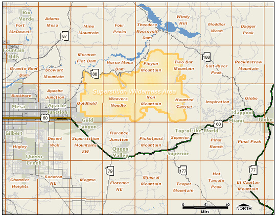
The map below shows the topographic quadrangles (7.5 minute) that cover the Superstition Wilderness and surrounding area. To download a pdf version of a given quadrangle, simply click on the appropriate quad name. If you do not have the Adobe Acrobat Reader®, you may download the free pdf viewer here.
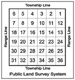 On most of these maps, you’ll see faint red grid lines, with each box labeled with a red number. These are Sections and serve as the basic unit of the Public Land Survey System (PLSS). Each Section is one square mile and contains 640 acres of land. There are 36 sections in each township, thus each township is 6 square miles. Townships are described by township and range lines. Township lines run east to west and measure north or south of a principal base line. Inversely, range lines run north to south and are used to measure east or west of a principal meridian. Use the following link to learn more about the Public Land Survey System.
Note: Official wilderness trails as well as miscellaneous routes have been added to the following topographic maps. Dotted red lines indicate unofficial routes (trails, pack trails, or even 4WD routes) and may not be accurate. Additionally, roads have been added. Solid gray lines indicate well maintained roads, and dashed gray lines are either partially maintained roads or 4WD routes that may or may not be accessible. Please contact the Tonto National Forest Service directly for current road conditions whenever driving into the backcountry.
Overview Map (click on quad names to view individual topographic maps)
Map created by AnalyGIS, LLC
| Trailhead Name | Directions |
Peralta Trailhead |
From Phoenix: Take US Hwy 60 east through the community of Gold Canyon. Turn east (left) on Peralta Road and drive about 8 miles to the end of the road. At the north end of the parking lot is the trailhead which provides access to the following trails: Peralta, Bluff Springs, and the Dutchman’s Trail. Peralta Road is a dirt road most of the way and can be slick and even washed out in sections after heavy rain.
|
First Water Trailhead |
Drive east on US Hwy 60 towards Apache Junction. At Exit 196, drive north one mile on Idaho Road to ST Hwy 88. Turn right on Hwy 88 and drive approximately 3.5 miles north to FS Road 78 (near Mile Marker 200). Turn right and follow this road approximately 3 miles. Note: Horse-trailers parking is on the left, about 0.5 miles before reaching the main trailhead. Trails accessed: Dutchman’s Trail (#104), and Second Water Trail (#236). |
Canyon Lake Trailhead |
Drive east on US Hwy 60, take Exit #196, and drive north one mile on Idaho Road to ST Hwy 88. Drive northeast for approximately 15 miles to the Canyon Lake Marina. Their parking lot may be utilized, with the trail access located on the south side of the highway. Use care when crossing the highway! Trail Accessed: Boulder Trail (#103). |
Tortilla Trailhead |
Drive east on US Hwy 60, take Exit #196 and drive north one mile on Idaho Road to ST Hwy 88. Drive northeast for approximately 22 miles to the Tortilla Road (FS Road 213) turn-off. Parking is available here. If you have a 4WD, you may follow this road approximately 2 miles to a dead-end. Trail Accessed: Peter’s Trial 105, JF Trail (#106), and Hoolie Bacon Trail (#111). |
Reavis Trailhead |
Drive east on US Hwy 60, take Exit #196, and drive north one mile on Idaho Road to ST Hwy 88. Drive northeast for approximately 28 miles to the Reavis Road (FS Road 212) turn-off. Turn right and follow this road 3 miles to the trailhead. Note: 4WD vehicles are needed for last 3 miles. Road not recommended for horse trailers. Trails Accessed: Reavis Valley Trail (#109). |
Woodbury Trailhead |
From Florence Junction, drive east on US Hwy 60 approximately 2 miles to the Queen Valley Road turn-off. Turn left and follow this paved road approximately 2 miles to where the Hewitt Station Road (FS Road 357) branches off to the right (gravel road). Follow this road for approximately 3 miles to the JF Road (FS Road 172) turn-off, turn left and follow this road approximately 9.3 miles to a road turning right. Note: Queen and Hewitt Creeks can wash out these roads. Drive with care. The trailhead is a short distance down this road. 4WD vehicles needed. Not recommended for horse-trailers. Trails Accessed: JF Trail 106 and Woodbury Trail 114. |
Rogers Trough Trailhead |
Form Florence Junction, drive east on US Hwy 60 approximately 2 miles to the Queen Valley Road turn-off. Turn left and follow this paved road approximately 2 miles to where Hewitt Station Road (FS Road 357) branches off to the right (and turns to gravel). Follow this road for 3 miles to the JF Road (FS Road 172) turn-off, turn left and follow this road 8 miles to the junction with the Roger Trough Road (FS Road 172A). Note: These roads are sometimes washed out so drive with care. Bear right and follow this very rough road approximately 3 miles to the trailhead. 4WD vehicles required. Not recommended for horse-trailers. Trails Accessed: Reavis Valley Trail (#109), West Pinto Trail (#212), and Roger’s Canyon Trail (#110). |
Miles Trailhead |
Drive northeast from Superior on US Hwy 60 approximately 4 miles past “Top-of-the-World.” Turn left on the paved Pinto Valley Mine Road (FS Road 287), which is east of the Pinto Creek Bridge. This road is through a mining area and is often confusing. Follow this road approximately 6.5 miles to the Miles Ranch Road (FS Road 287A) turn-off. Turn left on this road and drive approximately 5.6 miles to the trailhead. High-clearance vehicles needed. Not recommended for horse-trailers. Trails Accessed: West Pinto Trail (#212), and Rock Creek Trail (#195). |
Campaign (Upper Horrell) Trailhead |
From the junction of ST Hwy 188 and US Hwy 60, drive northwest on Hwy 188 for approximately 21.2 miles to the Cross P Ranch Road / FS Road 449 turn-off. Turn left and follow this road approximately 2 miles, turn left onto FS Road 449A and drive approximately 8 miles to the Trailhead. 4WD vehicles recommended. Trails Accessed: Reavis Gap Trail (#117), Campaign Trail (#256). |
Tule Trailhead |
From the junction of ST Hwy 188 and US Hwy 60 near Globe, drive north on Hwy 188 approximately 21.2 miles to the Cross P Ranch Road / FS Road 449 turn-off. Turn left and follow this road approximately 2 miles to a fork in the road. Turn to the right and follow this road approximately 0.75 miles to the Tule Trailhead. Trail Accessed: Tule Canyon Trail (#122). |
FS Road 83 Trailhead |
Unofficial trailhead that provides access to the Two Bar Ridge Trail (#119). From the junction of ST Hwy 188 and US Hwy 60, drive northwest on Hwy 188 for approximately 24 miles to the FS Road 83 turn-off. Turn left and follow this road approximately 4 miles to terminus. 4WD vehicles recommended. |